John & Anne Wiley

2016/06/20

3pm 6/19 Over Sherpa Fire

Filed under: Aviation,Flying,Happiness,Has Photos,Nature,Random,SB Region — John @ 00:38

I’ve just sent this to Edhat, and will try to post more and bigger pix later tonite:

We flew over the Sherpa Fire at 3pm Sunday and got a bunch of aerials. We’re in the middle of Father’s Day events but I wanted to shoot these off to Ed in case they have time to post them. I’ll put them on our blog too in case they’re too busy to post, because they show the whole burn area and though we’re seeing smoke in town the aerial views are very reassuring. In essence there are only half a dozen spot fires big enough to make a small visible smoke plume and they’re all inside the burned perimeter except one at the North edge that’s well-painted with PhosChek. In fact, while passing overhead we saw a small jet and then the DC-10 both do big drops to paint a bright red line above that edge. Lots of other pix including heli drop but I’ll put those on our blog later tonite.

7902787178077799

2016/06/18

Sherpa Fire Aerials

Filed under: Aviation,Flying,Has Photos,Nature,Random,SB Region — John @ 09:36

Sherpa Fire (aka Scherpa, Sharpa, Shirpa, Chirpa depending on whom you ask) turned out to be the focus of our “flight to Lompoc” (that we didn’t end up visiting). Soon after takeoff our almost normal view across Devereux Slough had a smoke line across the island mountains.

7322 Almost Normal

7322 Almost Normal

The colors were muted and shifted, but still lovely. Toward the Northwest though, things looked quite different.

7330 Different Picture

7330 Different Picture

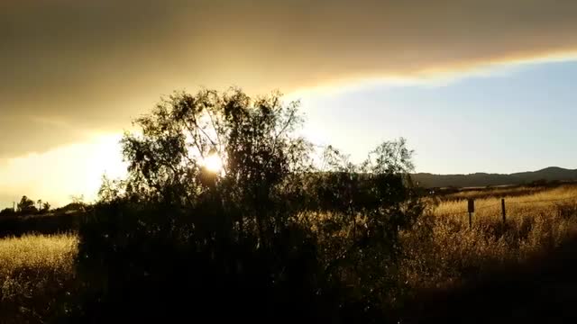
From distant El Capitan toward the North it looked more like doomsday. A big orange cloud rising with white wisps of smoke at the Western edge of this big fire.

7335 Orange Is The New

7335 Orange Is The New

The sun, moon and most of town has been painted orange by this smoke for days now as the Eastern edge is blown by intermittent bouts of fierce wind, ever closer to the city.

7361 Inexorable Approach

7361 Inexorable Approach

That hilltop on the right demonstrates what a blown ember can do by way of jumping ahead of the main fire.

7353 Hilltop Hop

7353 Hilltop Hop

A wider view gives an impression of the irregular shape of the burned area showing where firefighters took their stands, orange lines of PhosChek fire retardant dropped from planes, micro-climate winds, and shifts in prevailing winds in both direction and strength as the fire ran wild.

7379 Wider View

7379 Wider View

By the time we had climbed past the fire, far offshore to cede airspace to the fire aircraft, it was clear that the sky from Gaviota toward Lompoc was smoky and the town itself probably was too.

7396 Smoke Out West

7396 Smoke Out West

We decided to give up and turn back toward home, and this scene greeted us.

7399 Back Into Red

7399 Back Into Red

Blue sky above an ugly smear of red, with the tall white top of a heat surge from the awakening fire consuming a new area as we descended back below the layer of smoke.

7403 Red & White

7403 Red & White

By seriously tweaking some pix, I was able to clarify what had already burned on the Western end of the fire.

7410 Burned Area West

7410 Burned Area West

Here’s a wider view of the whole fire perimeter at about 4:20pm 6/17/2016 from about the same angle with the color and contrast more as the camera saw it, in case anyone wants to do their own tweaking.

7419 Sherpa Fire Perimeter

7419 Sherpa Fire Perimeter

Now a tweaked zoom closeup of the burned area above El Capitan.

7438 El Capitan Area

7438 El Capitan Area

Next a view of the burn area toward the North, showing nearly all but the Eastern end.

7459 Most Of Burn Area

7459 Most Of Burn Area

Now an update on the big active burn area at the Eastern end, including the spot fire hilltop.

7492 East Active Burning

7492 East Active Burning

Check out this closeup showing those tall flames shining through the thick smoke.

7504 Ring Of Fire

7504 Ring Of Fire

Another angle, across the burning hilltop and main active fire back toward the Northwest.

7511 Across The Burn

7511 Across The Burn

Here’s a zoom closeup through the heat waves, of that hilltop showing the fire vehicles at the left and some PhosChek on the hill crest beyond.

7518 Firefighter Hill

7518 Firefighter Hill

One last aerial view of that area, widened out to include helicopters working the main fire beyond.

7523 Air Attack

7523 Air Attack

We didn’t get any good pix of the massive DC-10, but it did a drop just before we took off and another after we landed. It flies here from Santa Maria airport where most of the aircraft activity is based, so our flight was probably during the time it took to fly back for a pit stop and return plus some time to line up the drop. The result if you look back through these pix, is the fire going from the monster we saw in flight to this tamed beast we saw before driving home from the airport.

7535 Calmer Beast

7535 Calmer Beast

Hopefully what we see at first light tomorrow will be less scary than what we’ve been seeing daily, and all our firefighters will be safe.

2016/06/17

Doom Cloud

Filed under: Has Photos,Nature,Random,SB Region — John @ 02:26

This cloud of smoke hanging over SB in late afternoon seemed to portend doom tonight, once the winds pick up and blast the Sherpa Fire out of control again.

7309 Smoke Eye

7309 Smoke Eye

The sun is reduced to an ominous red eye, and this wider view adds a smoke mouth making into some grotesque dirty white whale.

7312 Smoke Mouth

7312 Smoke Mouth

We were captivated enough to go across the “Bridge To Nowhere” aka Salvar Bridge that crosses Hwy.154 and the scene there was beyond words and pictures, so here’s a video. 194129 Wind, Fire, Drums//embedr.flickr.com/assets/client-code.js

2016/05/18

Whaling

Filed under: Flying,Happiness,Has Photos,Nature,Random,SB Region — John @ 19:08

As I kid I knew someone with a “Magic 8 Ball” toy. She’d ask it a question, flip it over, and like some hybrid fortune teller / magician, the answer would rise into view out of the dark depths. This experience reminds me of that somewhat.

6150 Rising Fortunes

6150 Rising Fortunes

Like some sign of rising fortunes, I glimpsed a dim shape beneath the water just offshore. Circling back and looking again moments later I could tell it was a whale, so we grabbed cameras and got views like these. Soon we realized it was probably that same group of two mothers with their calves making leisurely passes along the shallows, scooping up mud and filtering out meals.

6104 Less Mud

6104 Less Mud

Unlike before, we saw almost no mud coming from the mouths of the calves. Apparently they’ve either honed their technique with tutoring from moms, or can hold their breath longer so the mud is ejected before they near the surface. On one turn, a mom surfaced and her blow caught the sun in this magical rainbow.

6141 Whale Rainbow

6141 Whale Rainbow

Seeing them again bodes well for more “whaling” on our next local flight. If they stick around we might get to watch the youngsters continue to grow and learn.

2016/05/12

2 Tops & Bottom

Filed under: Flying,Happiness,Has Photos,Nature,People,Random,SB Region — John @ 22:33

Comments on an Edhat submission I sent in today got me wondering about this rooftop construction. Is it a jacuzzi, sculpture, or something completely different?

5780 UnJacuzzi

5780 UnJacuzzi

Could this actually be a jacuzzi? If you have ideas, please post a comment on the Edhat item. As you can see in the Edhat pic there’s a roof above with a patio that has things on it, so in case you were curious like me:

5782 Bottom Up

5782 Bottom Up

It’s two dead plants and disused tables. Probably an interesting story in itself, but I’m also curious about the bottom of that wall where they’re digging down for something presumably related to the steel beam construction at the bottom-left. The bottom referenced in my title for this post though, is about this pic of the ocean bottom in front of the popular More Mesa open space.

5501 More Mesa Bottom

5501 More Mesa Bottom

Do you share my fascination with how the colors and shapes combine there?

« Previous PageNext Page »

Create a free website or blog at WordPress.com.