John & Anne Wiley

2019/07/01

SY Valley Flight

Flying the Santa Ynez Valley is always interesting and fun, but often remarkably beautiful too. That was the case on this February flight, when we saw some effects from a welcome return of near-normal rain to our region. After the horrors of our monstrous Thomas Fire and subsequent debris flow, it was reassuring to see a light tinge of green on the barren mountains around Jameson Lake.

DSC_9311-b.jpg

9311 Jameson Hinting Green

Beyond the full lake and burnt mountains far into the eastern distance, snow on the farthest peaks filled our hearts with hope of a gentler 2019 Summer. To the North, unburned slopes just beyond the Santa Ynez River valley weren’t so far away.

DSC_9346-b.jpg

9346 Blued Green Beyond Brown

The different sun angle on moist air made those green slopes look more blue to the camera than to our refreshed eyes. We wondered how much of that still mostly bare foreground slope would erode down into the river valley lakes. Nearing the airport and town of Santa Ynez, the Bradbury Dam on Lake Cachuma was releasing a token amount of precious water to nourish the ground water and the river habitat.

DSC_9348-b.jpg

9348 Bradbury Water Release

Last up for this small selection of pix from that flight, I’ll offer a touch of how those distant snowy peaks looked to us. Unlike these flat two-dimensional camera pix, most people see in 3D. Even so, many people have trouble seeing 3D on a 2D medium like a standard tablet or computer screen. When I was a kid we once had a Viewmaster that made it easier. Recently we splurged on a few pair of $20 DLP Link 3D glasses for our inexpensive used Optoma projector to watch a few BluRay 3D movies on the 93″ screen. Anyway, that stimulated me to make up this 3D image of the snowy peaks.
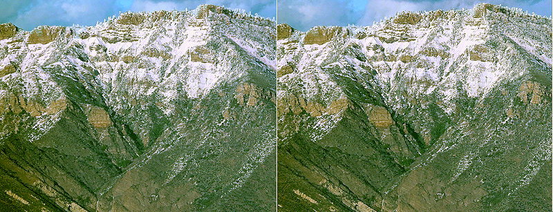
DSC00231-3D-b.jpg

0231 Deeper Peek at Peaks

Now since few people will have a Viewmaster or 3D projector, I’ve made this image for the “crossview” type of “free viewing” that only requires learning the trick. If you’ve followed this blog, my Photo Page, or Edhat posts for long, you’ve seen me share some 3D over the years. Many people have enjoyed them, and many others have been unable to master the trick. I recently came across an excellent Iowa State University crossview tutorial that might help. As always, feel free to use our Contact Us form to share your success (or frustration), or to let us know if you’d like me to share one of the 3D pix I’m creating for display using our new DLP Link 3D glasses. They’ll work on Optoma or any of the many compatible projectors (possibly not compatible with the much more expensive DLP Link TVs).

ps-Anne’s computer didn’t display the two most helpful “animated GIF” files in that ISU tutorial, so here they are in the hope you can see them here if not on that site.

What you perceive might be something like the animation below.
1-animation-b.gif

Since you learned distance control in step 1, align your four squares so that the two in the middle overlap. The “X” will help you do this with precision. What you perceive might be something like the animation below.
2-animation-c.gif

2019/05/26

Scene From Above

Here are a few more aerial views, starting with the geometry of field and stream in the CA Salinas Valley.

DSC05074-b.JPG

5074 Nature & Nurture

The last pic I ever snapped from Tripp was of the Laguna Blanca area of Hope Ranch on a smoky and hazy day, that for me evokes the mist of memory.

DSC05187-b.JPG

5187 Era’s End

As weather finally began to hint at drought relief, from a safe distance we enjoyed the look of clouds beyond the Santa Ynez Mountains.

DSC_8976-b.JPG

8976 Beyond the Divide

It’s nice having the long zoom lens of the Sony RX-10m4 for pix like these.

DSC09421-b.JPG

9421 Cachuma & Clouds

A few days later we enjoyed this somehow rakish view of Lake Cachuma.

DSC_9004-b.JPG

9004 Angles & Reflections

Though it was from a Cachuma dam release to replenish ground water in the Santa Ynez Valley, it was nice to see a thin strip of green amid bone dry scrub.

DSC09495-b.JPG

9495 Thirsty Land

2019/05/23

Restart

It’s surprising to me how much has happened since the last post here! So finally today a little time opened up to share more pix since the end of our last big Tripp trip to the Pacific Northwest and UK/EU airline adventures. We were deep in an epic drought back in July, with wildfires running amok and smoke hanging over our brown hills.

DSC04804-b.JPG

4804 Veiled Brown

People were enjoying our beaches though, like this one next to the marina.

DSC04966-b.JPG

4966 Shape of Water

August brought much more of the same.

DSC05007-b.JPG

5007 Watersports

Including wildfires that felt overwhelming despite the courage of firefighters rushing toward the dense smoke.

DSC05115-b.JPG

5115 Defender

August also sadly saw our last flight in beautiful Tripp. There’s a story in the performing arts about how to get the most from every show: make it for two people. The person seeing it for the first time, and the person seeing it for the last time. Though we hope to see many more flights in small planes in coming years, harvesting pix of familiar sights from that last Tripp flight is extra special now.

DSC05128-b.JPG

5128 Kelp Harvest

Hendry’s Beach (Arroyo Burro) evokes the relaxed mood in our zoom pix as we rode our magic carpet offshore that last time.

DSC05140-b.JPG

5140 Relaxing


2018/10/20

Tripp Trips

“The only thing constant is Change,” say the sages. So it is that we’ve sold our magic carpet, the Cessna 172Q named “Tripp.” This stalwart steed carried us safely all over the North American Continent, over the Rockies, and over water to Newfoundland, the Bahamas, and Alaska. She’s now joined a younger family with plans to fly Europe and Africa. That’s her new “dad” waving goodbye as he takes her East.

5246 Tripp East

5246 Tripp East

Before the sale was finalized and she joined her new family, we took Tripp on a last local flight. It was a “soft” hazy day, somehow perfect for our brief farewell to a treasured friend and phase of our aerial explorations.

5122 Soft Finale

5122 Soft Finale

To further soften this transition, we got re-acquainted with the SBFC Tiger AA5B and our old friend “Flash” the C-172M. In fact, we’ve already been taking brief local flights in both of them though so far we’ve favored Tiger. He’s a little faster than Tripp and climbs quickly to the local peaks for views like this.

9421 Tiger Treats

9421 Tiger Treats

We’ll miss the easy comfort, broader photo options and stability of Tripp, but her departure has brought us one more gift.

170927 Trip East

170927 Trip East

Cash from Tripp’s sale helped us afford a trip East to the UK & EU. I envy the flight she’ll take there, lower and slower. Down where we used to fly so intimately with the earth but not bound by it. The flight to London was higher than in this pic, and fast, flirting with darker daytime skies at the edge of space. Happily our three week adventure brought home many new and very different memories that I’ll post about next.

2018/07/19

Long Way Home

This trip seeing new facets of our beautiful planet in flight (intimately but not bound by it), visiting precious family & friends, and exploring new places… wasn’t all we dreamed. As with each of our trips, it reinforced a big life lesson that flying has brought us: embracing what Is. That comes to us in the differences between the trip we dream, plan, take, remember, and dream about after return. So of course it was both more, and less, than we dreamed or planned.

So it was that The Dalles dawned almost clear of the smoke that greeted our landing in yesterday’s dusk.

4297 Cleared Takeoff

4297 Cleared Takeoff

Climbing toward the West for a look at the famous Columbia Gorge, the pages of time formed a crumbling book on the North bank.

8658 Book of Time

8658 Book of Time

Other wizened formations evoked a castle with columnar basalt exposed at the base of the towers, reminding us of the volcanism still shaping this region.

8659 Stone Castle

8659 Stone Castle

A tributary I’ve not looked up the name of, also adorns the North shore of the mighty Columbia with rapids that test the best kayakers.

8670 Water Power

8670 Water Power

Relaxing when it combines with the Columbia, it releases on the banks much of the sediment it rushed downhill and polished its canyons with.

8672 Bank Deposits

8672 Bank Deposits

In the once more increasing smoke, distant Mt. St. Helens provided yet another ominous reminder of this region’s geologic activity.

8734 Napping Volcano

8734 Napping Volcano

In the river below our wings, some of the larger islands had buildings where Mark Twain might like to retire.

4314 Home Island

4314 Home Island

Even as the economy has diversified and changed, there are still large sawmills along rivers here.

4330 Busy Sawmill

4330 Busy Sawmill

To keep with our planned flight, we’d already climbed too high for a close look at the famous waterfalls in the gorge. Even so, this one looks good in a zoom pic.

4344 Waterfall View Rooms

4344 Waterfall View Rooms

Farther down river we could increasingly see clouds that we’d hoped would be clear, so we continued climbing to fly well above them.

8714 Cloud Complication

8714 Cloud Complication

The next waterfall we spotted looks more likely to be a popular public attraction. It continues above and below this section snapped between the trees.

4377 Spectacular Falls

4377 Spectacular Falls

Now it was obvious that the clouds lingering beyond the forecast along our route called for a high transit out to the coast where the air was clear and tailwinds were promised.

8739 More Clouds

8739 More Clouds

We took a last look at the river now far below, where locks and dams harness some of its energy.

8759 Columbia Dams & Locks

8759 Columbia Dams & Locks

After an alert but uneventful transit to clear air in the Roseburg area, we continued southwest to the coast and turned to follow it more directly toward home again. This is a beautiful region from the air, where we see many wonders hidden from the casual drive we so enjoyed before flying. Including of course the cave-garnished and weathered West side of the cliffs and countless islands of various sizes & shapes.

4467 Prince Island

4467 Prince Island

After enjoying an unfolding stream of such sights, soon we passed Shelter Cove and once again longed to land at 0Q5 and spend some time exploring the black sand beaches and other relaxing attractions there.

4519 Shelter Cove 0Q5

4519 Shelter Cove 0Q5

We could of course overwhelm you with many more pix of visual delights we thrilled to on this trip, but I’ll offer only two more. First another look at distant San Francisco from just offshore, included here even though it’s hazy from moisture and wildfire smoke. It’s an usually high perspective for us since ATC cleared us across the path of the airliner parade leaving SFO.

4592 SF From High

4592 SF From High

After a brief fuel stop at KWVI Watsonville, we began seeing the familiar hills and vineyards of home as sunset blushed the terrain around Atascadero.

4618 Warm Welcome

4618 Warm Welcome

Our tailwind topping Broadcast Peak provided a weather warning. Turbulence was sudden, though relatively mild since I’d slowed and remained high above the ridge. Only after reaching the coast did I descend into the stronger turbulence where air temperature went from the 60s to the 90s. Happily that was a short transition and we landed in the cool coastal breeze so common at KSBA. A very warm welcome home to our cool little hometown. 🙂

Next Page »

Blog at WordPress.com.