John & Anne Wiley

2013/03/12

Dreams & Schemes

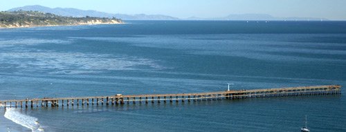
We’re ramping up. The dreams and schemes going into our Islander Adventure are pretty intense. So much to learn, plan, get, and do before we take off! Looking at this pic of Goleta Beach just now made me realize the Caribbean is going to look similar.

4742 Bahamaesque

4742 Bahamaesque

Both have beautiful beaches, ocean, boating, fishing, diving, swimming, and lots of blue. The sky here is often similar to pix I’ve seen of the Caribbean. But the ocean, not so much. Here it’s a deeper blue that’s more serene somehow, and there it’s brilliant and a lot warmer for water sports.

So today I’ve invested quite a bit of time figuring out the maximum distances we’ll be flying over water.
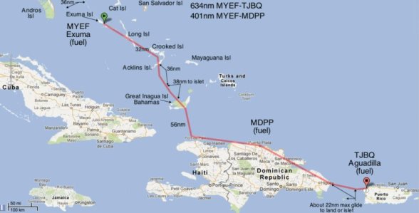
Water Crossings

Water Crossings

If you’re interested, you’ll probably need to click for the larger version to make any sense of this. In essence, it turns out the first water crossing from West Palm Beach to Grand Bahama Island (about half an hour) matches the one between Great Inagua and the little island just off Haiti.

Many (most?) pilots don’t worry about long water crossings, even in single-engine planes like Tripp. Lucky Lindy is oft quoted saying two engines just give you twice the chance of something going wrong. That’s fine, but more important to me are two things:

1)Engines have become vastly more reliable since Lindy’s adventure, and Tripp’s Lycoming 0360 is among the very best. Engine troubles of any sort on planes like Tripp are very rare. But the only sort of engine trouble I’d concerned about on a long water crossing is sudden and severe power loss, and that is much more rare still. Almost unheard of. Still, I do all possible to minimize that tiny chance.

2)I fly high. No, not in that sense, silly! Planes like Tripp glide quite well, serenely going about 1.5 miles per 1,000 feet of altitude. So unlike the innumerable pilots I see taking off from SBA toward Catalina past that scene of Goleta Beach (above) staying low as they head out over the water, I climb to always be within gliding range of land. Tripp is quite safe for going into water (for us that is – Tripp would probably eventually sink and become a fish refuge), so the concern is about being far from shore. Anyway, on those two long Caribbean crossings we’ll be beyond glide to shore for about six minutes. So even if the fickle finger of fate were to choose that moment to touch our trusty powerplant, we’d land near shore.

Now maybe you’ve never thought about this (or don’t want to!), but for me it’s a big part of contemplating a Big Adventure that includes big water crossings. If we do go beyond the Bahamas, it will be a small factor in our decision along with all the international ramifications of passing near Cuba and Haiti, possibly stopping in Dominican Republic, and visiting Puerto Rico and the British Virgin Islands.

2013/03/11

Winter

When we lived in the Pacific Northwest, a notion like flying across the continent to the Caribbean was very attractive on March 10. Today was a typical mid-70s crystal blue calm here, so Winter is a different visceral experience. We’re excited to finally visit that part of the world (a first for both of us), yet I wonder what weather we’re leaving this for.

4737 Hills of Home

4737 Hills of Home

Even looking out the window at scenes like this, it’s fun to focus on maps. I’ll be reading a lot about flying in the Caribbean, talking with pilots who do it a lot, and possibly even meeting up with pilots flying there at the same time. Meanwhile I spent some time this afternoon putting together a mosaic of maps to get a rough idea of the distances. Later I’ll plan some actual fuel stops and stretch breaks and we’ll choose our overnight stops. For the Florida Keys, it looks pretty simple compared with our Big Adventures all over the rest of the continent.

Keys Route

Keys Route

Between whim and weather, the actual route we fly will surely be quite different but this is a great place to start. When I see Key Largo on a planning map for our flight, the beauty outside right now dims into a very pleasant background. Looking at the Caribbean part of our upcoming Islander Adventure is even more enchanting.

Caribbean Route

Caribbean Route

You won’t be able to make much of this map unless you click to see the large version. But it’s dreamy to imagine visiting all those names I couldn’t locate before and adding them to our mental map of places we’ve flown over and landed. Bahamas, Freeport, Nassau, Turks & Caicos, within sight of Cuba, on to Haiti, Dominican Republic, Puerto Rico, and the Virgin Islands. Quite a quest. Quite an Adventure!

2013/03/09

Flying Colors

We flew over the fireworks at SB Harbor a few years ago and as you’ve guessed it was spectacular. Well today was even more so in some ways, because the show was silent and all-natural.

4911 Color Uptake

4911 Color Uptake

Again we were flying near the Harbor, but this time it looked as if color were being drawn out of the ocean up into the clouds. It was a post card for offshore oil platforms. Then in the hills over Carp I noticed a gray fuzz of rain. Realizing it was in full sun due to a hole in the clouds I turned toward the mountains to recreate the angle between us, rain and sun in the offshore rainbow. Well!

4926 Colorful Division

4926 Colorful Division

The lines between North and South, earth and sky, gray and color, mundane and ecstatic were all divided by this most brilliant rainbow I can ever recall. Maybe because we were fairly close, our sun angle was improved by being up in the air. Maybe just that our hearts sang with the joy of it. Whatever the causes, I’m glad to have these pix (plus others on Edhat and Photo Page) to share with you. What a beautiful world we wander, eh?

The colors of the rainbow,
So pretty in the sky,
Are also on the faces
Of people passing by…

Bob Thiele

2013/03/07

Why?

Sometimes when we go on Big Adventures we wonder aloud, “Why did we ever leave Santa Barbara?” It’s not that we’re snobs, nor that there aren’t other parts of the continent that are spectacularly beautiful. It’s not even all the excellent arts, culture and fun entertainments here. It’s not reason at all. Just a gut reaction when we fly over local scenes like this.

4731 Why Leave This?

4731 Why Leave This?

We live in a modest low-rent place so we can afford to be here, and we scrimp on everything else so we can fly. But maybe we still enjoy it more than some of the people living high on the hillsides in mansion estates like these.

4729 High Life

4729 High Life

I guess the secret to happiness is being happy with where you are and what you have.

2013/03/06

Islander Adventure

Well, we’re seriously talking about another Big Adventure. This one we’re calling our Islander Adventure because our biggest new destination is the Bahamas. Getting there would involve flying about 55 miles across the water from West Palm Beach, Florida.  About five minutes of that flight would be beyond gliding distance to land, but the water’s warm and there are lots of boats that could give aid. We have lots of planning and packing to do, both before we go and along the way. Here’s our initial idea for a route.

Islander Adventure Route

Islander Adventure Route

As you can see (a little more clearly if you click to view the largest version) we also hope to fly the Florida Keys, and go beyond Bahama possibly all the way to the Virgin Islands. The southern route across the country would of course be our likely path East, coming home on a more northerly route. In case you’re wondering about the little jag on the border at Texas, that’s Big Bend that looked fascinating from a distance when we landed at Marfa, TX.

Weather will pretty much decide our timing and route. Like when an overnight stop on Prince Edward Island turned into a week. Or when we went to lovely Dubuque, IA because we couldn’t get any further from Iowa City where we’d taken off half an hour earlier.  So I smile looking at this map.

Whim will be the second largest factor. “Oh, that looks interesting,” has led to many diversions on our prior Adventures. What sorts of whims will we encounter in this Islander Adventure?

Islander Whim

Islander Whim

We’re bringing “Sev” our new Nexus 7 tablet with the great free Avare aviation app that’s going to pay for Sev with savings on FAA charts and documents, while making them much easier to use in flight. Maybe Anne will post some notes here on Sev along the way, and I’ll hopefully do some here on my MacBook named “Art.” Even if our words and pix aren’t interesting for anyone else, they’re fun for us to read because they bring back a flood of wonderful memories. Hope you’ll enjoy flying along with us! 🙂

« Previous PageNext Page »

Blog at WordPress.com.