John & Anne Wiley

2009/12/03

Around Home

Filed under: Flying,Has Photos,SB Region — John @ 10:28

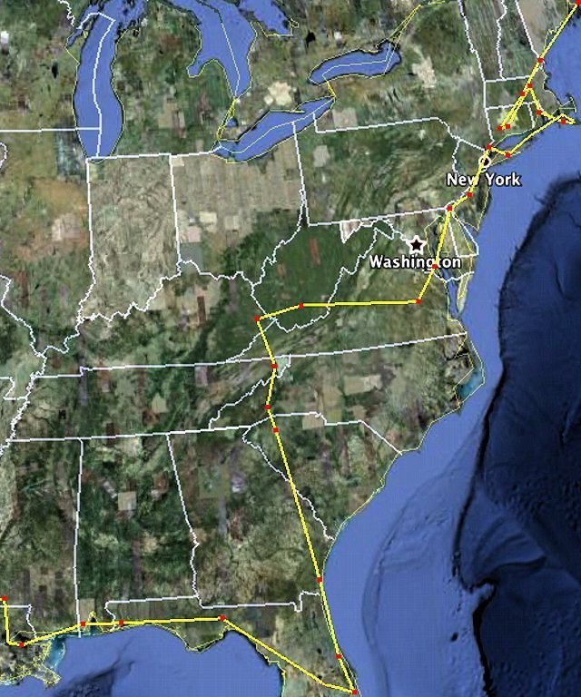
We’ve been home for almost a month today, and still seem to be resting around home a lot. Gradually though, we’re putting the house back together and getting out more. For a variety of reasons, before our Big Adventure we’d made quite a mess of our place. When we returned and added a plane-load of stuff, it was almost overwhelming.

Happily, we’ve not only put it all back together but done some cleaning and organizing chores we’d been putting off for years – and we seem to still be going. We’ve hosted several visitors and more are headed our way. In between, we’ve been taking drives including one along El Camino Cielo from Montecito to Hwy. 154 – one of our favorite perspectives on home because you get spectacular views in every direction.
We even took a short local flight just before Thanksgiving, landing at Santa Ynez and Santa Paula. It felt like “home” in a strange way, to climb into Flash and take off with only a general idea of where we’d go. We saw familiar territory with fresh eyes, and discovered things like this barn that’s obviously many years old.
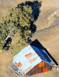
How then had neither of us ever noticed it after descending low over it for hundreds of landings at the Santa Ynez airport perhaps a quarter-mile away?
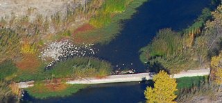
Taking off again we noticed a bridge or dam across the river flying from this familiar airport past the familiar Lake Cachuma.
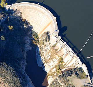
Continuing up the valley, at Gibraltar Lake we noticed for the first time that there are small trees growing from that dam’s concrete shoulder.
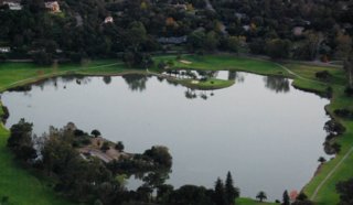
By the time we approached SBA at sunset, it felt as though we’d been gone several weeks again. Familiar places within a mile or two of home looked different, like peaceful Laguna Blanca in Hope Ranch where the shadows of night settled beneath us.
As the start of 2010 approaches, we have refreshed yet again our sense that “there’s no place like home.”

2009/11/13

The Other Third

Filed under: Big Adventure — John @ 02:15
Update 12/02/2009: This is the last post about our 5-week flight across the U.S., and to read it in sequence you can click here.

This is an approximation of the other third of our path on this Big Adventure, the part from Maine down to Florida and to Mississippi where the actual GPS track starts. You’ll notice we backtracked a bit in the Northeast by going to CT for a few days (and two different airports in Waterbury), then back up to MA, down to RI, across to Martha’s Vineyard (MA again), out to Nantucket and back, up to Hyannis and then down to Long Island. For simplicity our three jaunts along the Hudson (down and back one evening, then back down the next day on our way to DE) are shown with just one line.
If you’re interested in the larger-size versions of these three maps, download them because I’ll be deleting them from the Photo page in a few days (these smaller versions will still be here on the blog, but you can’t really see much at this size). If you don’t know how to download them, I put directions in the description for this most recent one on the Photo Page (click the thumbnail photo to see the medium size with the directions, then click the “All Sizes” icon at the top margin of the medium pic to see the full size one and download it per the directions that you read on the medium size one – Won’t it be nice when computers can talk like on Star Trek?)

2009/11/11

Hops To Maine

Filed under: Big Adventure — John @ 21:16

The white line is an approximation of our track from Santa Barbara to Bar Harbor, ME. The red dots are airports. From Prescott we went toward Chaco Cyn before turning direct to Santa Fe even though that leg shows as a straight line, and of course there were plenty of other places where we wandered to look at stuff that caught our fancy. I did include the major detours to look at Pittsburgh and the Fall colors in northern New Hampshire.

Partial Return Track

Filed under: Big Adventure — John @ 09:31

Above is a track from the GPS that shows part of our return path from MS to CA. Unfortunately, most of the trip was lost due to the GPS only holding the most recent portion and deleting the rest. Had I but remembered this “feature” it would have been easy to create a new track every day or two and have the whole trip. I’d planned to use the GPS track for figuring out where each photo was taken, but that’s not going to happen. Instead we just have our fading memory of where each place was. I can figure out some stuff based on written records and the time stamps on our photos. sigh…

Airports Visited

Filed under: Aviation,Big Adventure,Flying — John @ 08:52

Here are the places we landed after leaving Santa Barbara, in sequence. First is the airport code, for example SBA, then the airport name, Santa Barbara in this example. In cases where the city name isn’t clear from the airport name, like Love in Prescott, I’ve added the city name in parentheses. As you might guess, we chose some airports just for their fun names such as Las Vegas in New Mexico.

California:

CMA – Camarillo, MYF – Montgomery (San Diego), RNM – Ramona

Arizona:

PRC – Love (Prescott)

New Mexico:

SAF – Santa Fe, LVS – Las Vegas

Texas:

DHT – Dalhart

Oklahoma:

O45 – Hooker

Kansas:

LBL – Liberal, 9K8 – Kingman

Missouri:

EVU – Northwest MO Rgnl (Maryville)

Nebraska:

FNB – Brenner (Falls City)

Iowa:

IOW – Iowa City, DBQ – Dubuque Rgnl

Minnesota:

CHU – Houston County (Caledonia)

Wisconsin:

JVL – Southern WI Rgnl (Janesville)

Illinois:

PWK – Chicago Executive

Indiana:

3HO – Hobart

Michigan:

BEH – SW Michigan Rgnl (Benton Harbor)

Ohio:

AKR – Akron Fulton

Pennsylvania:

BFD – Bradford Rgnl

Vermont:

DDH – Morse State (Bennington)

New Hampshire:

EEN – Dillant-Hopkins (Keene)

Maine:

BHB – Hancock County (Bar Harbor)

New Hampshire:

PSM – Portsmouth Intl

Massachusetts:

ORH – Worchester Rgnl

Connecticut:

OXC – Waterbury-Oxford

MMK – Meriden Markham

Massachusetts:

6B6 – Minute Man (Stow)

Rhode Island:

PVD – Green State (Providence)

Massachusetts:

MVY – Martha’s Vineyard

New York:

ISP – Long Island Macarthur

HPN – Westchester Co (White Plains)

New Jersey:

VAY – South Jersey Rgnl (Mount Holly/Lumberton)

Delaware:

ILG – New Castle (Wilmington/Newark)

Maryland:

2W6 – St. Mary’s (Leonardtown)

Virginia:

RIC – Richmond Int’l

West Virginia:

BKW – Raleigh County (Beckley)

Kentucky:

PBX – Pikeville

Tennessee:

0A9 – Elizabethton

North Carolina:

AVL – Asheville

South Carolina:

GMU – Greenville, 99N – Bamberg County

Georgia:

09J – Jeckyll Island

Florida:

7FL6 – Spruce Creek, MLB – Melbourne, TLH – Tallahassee, PNS – Pensacola

Alabama:

2R5 – St. Elmo

Louisiana:

DRI – Beauregard Rgnl (De Ridder)

NEW – New Orleans

Mississippi:

MCB – McComb

Texas:

AUS – Austin, SAT – San Antonio, MRF – Marfa, ELP – El Paso

Arizona:

MZJ – Pinal (Marana), E60 – Eloy

California:

BLH – Blythe, IZA – Santa Ynez, SBA – Santa Barbara

« Previous PageNext Page »

Blog at WordPress.com.