John & Anne Wiley

2015/07/28

Pajaro to Capitola

We attended a sweet simple family wedding on the beach at Pajaro Dunes some years ago, so we always enjoy seeing it when we fly that section of coast.

5289 Pajaro Dunes Homes

5289 Pajaro Dunes Homes

Even looking at this pic evokes dream memories mingling surf sounds with deep sleep in one of these rental cottages. Up the beach a ways, swimmers were completely unaware of the dark shape of a tight school of fish huddling against the hungry gulls.

5239 School Gulls

5239 School Gulls

Manresa State Beach seems to demonstrate a problem with so many of us loving these beaches, combined with current agricultural methods.

5231 Manresa Algae Bloom

5231 Manresa Algae Bloom

Those dark shapes that look similar to an oil spill are probably algae blooms triggered by high nutrient levels in the warm water. At Seacliff in Aptos is the “cement boat”  that we found so intriguing as kids, unaware of its story way back to WWI.

5226 S.S. Palo Alto

5226 S.S. Palo Alto

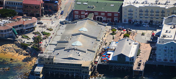
Capitola has built up its little waterfront into quite a tourist attraction, making us want to visit again and see the changes at what claims to be the oldest beach resort on the West Coast.

5218 Capitola

5218 Capitola

2015/07/27

Marina to Moss

The little town of Marina on the coast just North of Monterey is home to a quiet little airport we’ve visited a few times. On the outskirts is a Cement plant with this enigmatic rusty old dredge that seems to be maintaining a small beach side pond.

5325 Marina Pond

5325 Marina Pond

The colors of Salinas River not far beyond delight the soul with impressions of silence augmented by bird song and surf.

5323 Salinas River

5323 Salinas River

Here and there we saw individuals and groups horseback along the beach, and this woman alone trying to coax her reluctant ride to feel the foam.

5322 Timid Horse

5322 Timid Horse

There was another white horse on the balcony of the old antique shop across from the Post Office on the edge of Moss Landing, but it doesn’t move.

5307 Fiberglass Horse

5307 Fiberglass Horse

I’d never seen this next view of the iconic little town until a couple of years ago. Yet it somehow evokes memories of my youth exploring this town with dates, or glimpsing the power plant smokestacks from Hwy.1 or the more distant 101 freeway. So much has changed, yet so little.

5303 Moss Landing

5303 Moss Landing

2015/07/26

Moist Monterey

If there’s fog or low cloud anywhere along the coast North of Santa Barbara, you’ll generally find some of it around Monterey. In addition to the fluff we saw in the prior post here, the air over the whole peninsula was a close cousin of cloudy: hazy. So the dozens of pix we snapped there mostly didn’t come out well even though the views we enjoyed were spectacular. Still, here’s a look at Lucas Point, past Pacific Grove and out across the bay.

5444 Pacific Grove

5444 Pacific Grove

Turning the corner we passed this popular place with the particularly romantic name, where we once enjoyed a quiet picnic and stroll.

5429 Lover's Point

5429 Lover’s Point

Here’s a different perspective on about two-thirds of what’s probably the best known attraction with Monterey in the name: The Monterey Bay Aquarium.

5415 Monterey Bay Aquarium

5415 Monterey Bay Aquarium

It’s in the most glitzy and touristy part of what was once accurately named Cannery Row, with few reminders of the lineup of fish canning factories it had been.

5406 Cannery Row

5406 Cannery Row

Here’s a wide view from Cabrillo Point to the docks, and the mountains of Big Sur beyond.

5421 Docks to Cabrillo

5421 Docks to Cabrillo

Last for today, a look back past Seaside and Sand City to the Monterey Regional Airport (KMRY) where we’ve landed only once or twice but usually hear private jets talking to ATC as we pass. The friendly people in that control tower cleared us to make this luxurious transition along their scenic shores.

5359 Sand to MRY

5359 Sand to MRY

2015/07/25

Yankee to Cypress

Yummy photogenic Yankee Point treated us to a rainbow in the few low clouds huddling along the rugged shore where mansions cluster close to the untamed cliffs.

5507 Yankee Point

5507 Yankee Point

Point Lobos pointed the way beyond Carmel and across Monterey to the distant bay.

5483 Point Lobos

5483 Point Lobos

Near a beautiful beach the Carmelite Mission offers an ideal location for soul soothing strolls.

5475 Carmelite Mission

5475 Carmelite Mission

There are some pretty impressive mansions in the Pebble Beach area, though most are hidden from roads.

5467 Pebble Panorama

5467 Pebble Panorama

Cypress Point might be both heaven and hell for golfers with hazards ranging from strong unpredictable wind to flocking and nesting birds and perhaps a few aggressive pinnipeds. At least it’s a great place to pause and relax if the stress gets to you.

5466 Cypress Point

5466 Cypress Point

Along this part of the famous 17 Mile Drive are some great viewing spots like this next one, where you can see tourists standing agape at the top of the pic. But few other than golfers know about that tiny sheltered sand beach below the green on this side of the fence.

5459 CP Secret

5459 CP Secret

Looking back, this seems as good a spot as any to bid goodbye for now to the abundant spectacles of beautiful Big Sur.

5453 Bye Bye Big Sur

5453 Bye Bye Big Sur

2015/07/24

Soberanes to Malpaso

The area around Soberanes Point is rocky. The shoreline is rough and riddled with sea caves yet the road is fairly close, lower, and more gently curving.

5529 Soberanes Point

5529 Soberanes Point

The cliffs look small, but as you can see in this next pic from the house inset at left for scale the cliffs are pretty tall.

5525 Cliff Scale

5525 Cliff Scale

In case you hadn’t already guessed, despite looking very much like an inset, it’s an actual house (mansion?). That shows how high these cliffs really are. Here’s a less strange looking pic showing some homes next door along the Aurora Del Mar frontage road.

5523 Aurora Del Mar

5523 Aurora Del Mar

In some places here there are beautiful sheltered tiny private beaches, many with soft sand between the rocks. Even though fairly high above the high water line, many of these buildings probably get quite a pounding from big storms. Window washing must be a daily chore, to maintain these amazing ocean views.

5521 Micro Beaches

5521 Micro Beaches

Now we reach Malpaso Creek, which again some say marks the end of Big Sur because it’s the start of the large Carmel Highlands area. At first glance I thought it was also the end of Big Sur’s beautiful concrete arch bridges from the 1930s.

5520 Stepped Bridge?

5520 Stepped Bridge?

But in the full-resolution version of this pic I can see that the white “step” outline is just a plastic cover over scaffolding. Apparently this bridge is getting some repair work. There’s a lovely beach here, complementing the sea caves to its right and left.

« Previous PageNext Page »

Create a free website or blog at WordPress.com.