John & Anne Wiley

2013/03/27

Carib Be In :)

Well, we went for it as you guessed. Took off from St. Augustine and flew over the fort we’d only seen from afar yesterday.
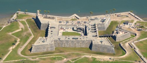
0699 St. Aug. Fort

0699 St. Aug. Fort

Also over the tourist part of town we’d wandered the night before while waiting to meet up with sweet Lettie and cool Roy for dinner. Turns out this is the oldest town in the country, and they have some fascinating archeological digs going on dating back into Spanish, French, English and American history.

0715 Tourist Quarter

0715 Tourist Quarter

Then down the coast at 1,500′ to 2,500′ intending to land at Vero Beach to top off fuel and take a stretch. Pretty constant light turbulence, but from what I’d seen forecast for winds aloft I thought it would be worse higher and with more crosswind slowing us down. I was so busy wresting with up/downdrafts I almost blundered into this restricted area over Cape Kennedy.

0742 Rocket Science

0742 Rocket Science

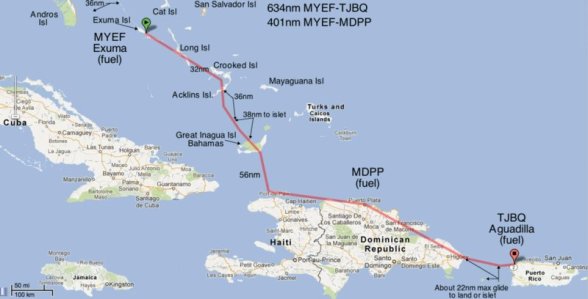
Since winds were plenty strong even low, we decided to just go for it and pay half again as much for fuel on the islands. That turned out to be a good decision, because once we started a gradual climb we were out of the turbulence by 5,000 feet. Again we picked up an express ride at higher altitudes, and up at 12,500 mid-crossing we topped out about 170kts. We were surprised how close both the island and the mainland looked from that high at mid-crossing. The crossing took only a few minutes before we passed this tip of Grand Bahama Island and turned descending toward Freeport.
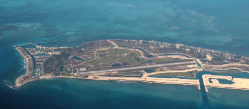
0762 Landfall

0762 Landfall

Florida had several thick smoke plumes from what appeared to be agricultural burns, and over the island they spread into a high smoke layer that hung over everything.

0763 Smoke High

0763 Smoke High

I quickened our descent to get below it for a better look at the island, only to find that they had fires of their own feeding the layer. Luckily downwind of our turn back toward the airport after touring the town.

0816 Expected Colors

0816 Expected Colors

Down here the colors were more what we expected from the tourist pix we’ve seen. Before long the friendly and helpful guys at ATC had us on the ground. They had me land with a strong and gusty quartering tailwind, but that just made it more fun for me. 🙂

Also wanted me to taxi clear to the end of the long single runway and then all the way back to the customs office at the terminal. Maybe the connecting taxiways were unusable, or they just like you to burn gas. I never did ask what that was about, but wished the tower had told me in advance so I could have landed at the end to look around longer and shorten the taxi.

Update: Pilots can find more details on flying the Caribbean in this thread I started on POA.

Waiting for us on the ramp was the super friendly, soft-spoken and helpful Daron who kindly posed with us for this documentation of our first Caribbean landing. If you ever land there, please tell him you saw his photo here and treat yourself to his disarming non-posed smile. 🙂

0057 Darren & Admirers

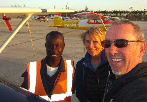
0057 Daron & Admirers

2013/03/22

Orleans!

We’re settled into our hotel in the Big Easy, and got this special clearance from ATC to fly past the city to Lakefront Airport (the runway sticks out into the lake in the distance, just right of center).

0247 N'Orleans

0247 N’Orleans

We often fly low and slow, but today was sort of low, fast and slow. Low in order to avoid the stronger quartering headwinds just above our minimum altitude of 1200 feet or so. Fast (100kt., faster than usual for us) trying to compensate for our relatively slow progress across the ground, and of course slow (actually our preferred pace of 80kt.) ground speed due to that same wind. Pretty smooth, and a little longer than we’d have most liked for this leg. But among the advantages was closer looks at things like this.

0223 Whazzat?

0223 Whazzat?

A small lake in a vast marsh was dotted with dozens of these things. Duck blinds? Fishing platforms? Gator traps? You tell me. As we climbed a little approaching the busy New Orleans airspace I told ATC I’d like to fly near roads because I’m unfamiliar with open marsh lands and didn’t want to be a gator snack. He didn’t laugh, nor could I detect even a smirk as he came back with, “Fly 090 degrees at 3,000 feet.”  In other words, shut up and do what I say. I did. 🙂

But I’ve jumped ahead. We woke to this beautiful scene in Galveston.

0023 Galveston Beach

0023 Galveston Beach

Christian and Danica at the airport had not only set us up with a nice hotel (Great, if it only had free wifi like every other place – even Starbucks!). They also loaned us a nice van this morning for a drive around town. So we got to see some of the old buildings that have survived hurricanes that all but wiped this low spit of land clean. Like the old Opera House, which I liked this painted back view of better than the front.

0067 Galveston Opera

0067 Galveston Opera

Anne liked the fanciful buildings and touches like this arch, and the nearby cruise port district.

0043 Playful Arch

0043 Playful Arch

Anyway, on our low, fast, slow flight we also saw the massive refinery complex at Port Charles. This tiny portion somehow reminds me of milk. Certainly not the color, I’m talking about when I was a kid and thought milk came from cartons and then got grossed out when I leaned it’s actually the steaming exudation of a smelly animal.

0153 Black Milk

0153 Black Milk

Since I loved milk, especially with fresh-baked cookies, I soon forgot my distaste for the origins and then got curious about the whole dairy process. Even helped a farmer milk his cows before dawn once and tasted the incomparable sensory experience of really fresh milk. So this pool of hideous black goo is part of the process that makes the “milk” Tripp likes best. Still, I’ll be glad when the aviation biofuel production process is finally ramped up, and even happier when most small planes are electric or at least hybrid powered.

0182 Rice? Fish? Shrimp?

0182 Rice? Fish? Shrimp?

Nearby are large tracts of flooded farm land like this, that I suppose are for farming fish, rice, or shrimp. Which of course got me thinking of how this mixes with the black goo in hurricanes. Remarkable how powerful the forces of nature are, both for mixing these things up and for repairing the damage with new life.

Another discovery today was several places like this. Want to know my guess as to what it is?

0210 Double Parking

0210 Double Parking

I think oil workers drive here, park their cars, walk to one of those helipads, and are flown out into the Gulf for a shift working on a rig.

Well, we’re off to explore the French Quarter…

2013/03/20

Bending the Curves

Well, it took me a long time to take care of other stuff and then sort out the pix. We both shot a lot of pix at Big Bend, and the file numbers overlapped so I had to manually sort everything from two cellphones and three cameras. When I was a kid our family had one camera, and my sister hoarded it. Now most people have several, and photophiles like us have even more. Here’s why. 🙂

5216 LC View

5216 LC View

We woke to the majestic mountains of Las Cruces, thanks to Becky who gave us this view room at a bargain rate. We got a clearer look later, but farther away due to hustling to make up for time lost preparing charts at the airport preventing my intended detour for a closeup.

5219 LC Departure

5219 LC Departure

Fili, the wonderful man who drove us in the hotel shuttle back to Tripp said something he loves about living in Las Cruces is going to orchards in the green belt along the river on hot days. Here’s an overhead view I like of a home nestled among the bare trees.

5226 Green Belt

5226 Green Belt

Later at Big Bend, Anne told me to snap this landscape because it was on my side of the plane and she really likes the combination of colors and textures.

5300 Devil's Playground

5300 Devil’s Playground

Heavenly places like this get a bad rap in their Anglo names sometimes it seems to me. When there’s time I want to look up the native and Spanish names for this. When we took a very refreshing stretch break thanks to Marty, I learned something after she and Marcos graciously posed for this lively pic.

5315 M&M with A&T

5315 M&M with A&T

I love how M&M are both holding onto Tripp. They’re both excellent pilots and part of their excellent airplane collection is in the open hangar behind them. Well what I learned is that the spot Anne loved so much in the pic above, is the absolute fav of both M&M and several other local pilots. Wish we’d had time to descend and get a better look! But a sudden storm was brewing and we wanted to see more of Big Bend before dark. So glad we did!

5350 Into Mexico

5350 Into Mexico

Not long after leaving their private airport (3TE8) and warm Texas hospitality I got this view into Mexico with a shaft of light through the clouds gracing a river that joins the Rio Grande. By far my fav pic of the delightful day. Later as we neared Terrell Airport (6R6) for our turn direct to San Antonio, the sunset gave me one last memory of this amazing day.

5430 Farewell 3/19/13

5430 Farewell 3/19/13

2013/03/12

Dreams & Schemes

We’re ramping up. The dreams and schemes going into our Islander Adventure are pretty intense. So much to learn, plan, get, and do before we take off! Looking at this pic of Goleta Beach just now made me realize the Caribbean is going to look similar.

4742 Bahamaesque

4742 Bahamaesque

Both have beautiful beaches, ocean, boating, fishing, diving, swimming, and lots of blue. The sky here is often similar to pix I’ve seen of the Caribbean. But the ocean, not so much. Here it’s a deeper blue that’s more serene somehow, and there it’s brilliant and a lot warmer for water sports.

So today I’ve invested quite a bit of time figuring out the maximum distances we’ll be flying over water.

Water Crossings

Water Crossings

If you’re interested, you’ll probably need to click for the larger version to make any sense of this. In essence, it turns out the first water crossing from West Palm Beach to Grand Bahama Island (about half an hour) matches the one between Great Inagua and the little island just off Haiti.

Many (most?) pilots don’t worry about long water crossings, even in single-engine planes like Tripp. Lucky Lindy is oft quoted saying two engines just give you twice the chance of something going wrong. That’s fine, but more important to me are two things:

1)Engines have become vastly more reliable since Lindy’s adventure, and Tripp’s Lycoming 0360 is among the very best. Engine troubles of any sort on planes like Tripp are very rare. But the only sort of engine trouble I’d concerned about on a long water crossing is sudden and severe power loss, and that is much more rare still. Almost unheard of. Still, I do all possible to minimize that tiny chance.

2)I fly high. No, not in that sense, silly! Planes like Tripp glide quite well, serenely going about 1.5 miles per 1,000 feet of altitude. So unlike the innumerable pilots I see taking off from SBA toward Catalina past that scene of Goleta Beach (above) staying low as they head out over the water, I climb to always be within gliding range of land. Tripp is quite safe for going into water (for us that is – Tripp would probably eventually sink and become a fish refuge), so the concern is about being far from shore. Anyway, on those two long Caribbean crossings we’ll be beyond glide to shore for about six minutes. So even if the fickle finger of fate were to choose that moment to touch our trusty powerplant, we’d land near shore.

Now maybe you’ve never thought about this (or don’t want to!), but for me it’s a big part of contemplating a Big Adventure that includes big water crossings. If we do go beyond the Bahamas, it will be a small factor in our decision along with all the international ramifications of passing near Cuba and Haiti, possibly stopping in Dominican Republic, and visiting Puerto Rico and the British Virgin Islands.

2013/03/11

Winter

When we lived in the Pacific Northwest, a notion like flying across the continent to the Caribbean was very attractive on March 10. Today was a typical mid-70s crystal blue calm here, so Winter is a different visceral experience. We’re excited to finally visit that part of the world (a first for both of us), yet I wonder what weather we’re leaving this for.

4737 Hills of Home

4737 Hills of Home

Even looking out the window at scenes like this, it’s fun to focus on maps. I’ll be reading a lot about flying in the Caribbean, talking with pilots who do it a lot, and possibly even meeting up with pilots flying there at the same time. Meanwhile I spent some time this afternoon putting together a mosaic of maps to get a rough idea of the distances. Later I’ll plan some actual fuel stops and stretch breaks and we’ll choose our overnight stops. For the Florida Keys, it looks pretty simple compared with our Big Adventures all over the rest of the continent.

Keys Route

Keys Route

Between whim and weather, the actual route we fly will surely be quite different but this is a great place to start. When I see Key Largo on a planning map for our flight, the beauty outside right now dims into a very pleasant background. Looking at the Caribbean part of our upcoming Islander Adventure is even more enchanting.

Caribbean Route

Caribbean Route

You won’t be able to make much of this map unless you click to see the large version. But it’s dreamy to imagine visiting all those names I couldn’t locate before and adding them to our mental map of places we’ve flown over and landed. Bahamas, Freeport, Nassau, Turks & Caicos, within sight of Cuba, on to Haiti, Dominican Republic, Puerto Rico, and the Virgin Islands. Quite a quest. Quite an Adventure!

« Previous PageNext Page »

Blog at WordPress.com.