John & Anne Wiley

2010/08/10

Counting

We had some fun in the wee hours last night, tallying up some stuff from our N by NW trip. Looks like about 9,600 miles covered in about 77 hours of flying. About 40 minutes of that flying was in darkness over familiar terrain. We flew in light to negligible rain four or five times, once in moderate rain, once in light hail, and nearly all of the trip in some amount of visible smoke or haze. Today on the smoke maps I notice that nearly all of our route is no longer shown with significant smoke, and once the fog cleared this morning our mountain view is deliciously crisp (we’re talking about taking an evening “homecoming” flight to enjoy the clear air!). We had ten nights in hotels and eight camping, including our little experiment: sleeping in Tripp.

That was at Terrace, when we decided to try out the cozy bed for two idea we’d heard from an expert SBA pilot. By rearranging stuff with the rear seat back removed, you can create a nice platform from the rear baggage area up to the front seat backs. I put bungees on to keep the front seat backs tilted forward, and inflated a twin-size airmat that was slightly squeezed where it entered the rear baggage area for four inches or so where the width tapers toward the tail. Looked pretty good. It wasn’t! The airmat took up too much of the small vertical space inside the tail baggage area, so it was impossible to roll over without pointing your toes. It was also too short for my 6’1″ without keeping my knees bent, and for two people the art of synchronized turning is also required. That was a very brief and troubled sleep, and it ended with an intense claustrophobic gasp that woke us both. It took a moment to realize it had come from me, and then I devoted a minute or two to meditation on transcending the illusion of inability to breathe, and after a very brief and groggy convo we decided to exit the aircraft. While I was struggling to invent a means of escape other than slithering face-first down the landing gear, Anne in one deft “Houdini” movement was standing outside wearing an especially broad smile as she danced and stretched. We then put up the tent and slept soundly for another two hours until the tent gradually collapsed onto my face, though that event was more quickly and easily resolved by just relocating on the luxurious padded queen-size airmat until the tent encroachment was avoided. As we’ve already written, the sleep ended a few hours later when airport security informed us in perfect Canadian etiquette that we needed to move everything back another 20 feet from the taxiway. In case you’re wondering, the tent collapse was due to the pockets that hold the poles having holes in them (thus the poles slip until the tent eventually stretches out flat on the ground with poles protruding through the pockets, though we woke before that happened).

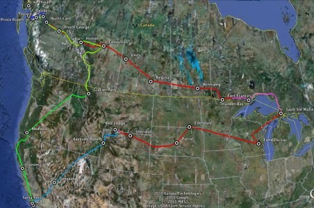
Anyway! Here’s a map with our actual GPS track, except for a couple of small voids where I was futzing with the GPS and one short stretch hand-drawn where I’d forgotten to start a new track before the current one hit max and began deleting the end. The result of that was a long caterpillar shape moving across the continent with a growing gap behind it that no longer showed where it had been. Had I not remembered to do the two or three clicks to fix it, we’d have only the last 1/4 or so of our adventure from the GPS. I’ve added the airports we stopped at, for context.
GPS Tracks With Airports

GPS Tracks With Airports

Our longest flights were about 4-5 hours, and our longest day (with two flights) was probably from Medford home with the refreshing lunch stop at Sonoma. Most days were a leisurely 2-3 hours of flying, with lots of diversions here and there to look at stuff and some fun convos about where and when to take our next stop. Several times we planned a stop and then changed plans on a whim, based on the looks of our intended destination, or when weather (including smoke) invited us to reconsider.

You’ll recall that we landed at some of the airports (and some cities) more than once so here’s the complete list of our 29 landings since leaving SBA, in sequence:
Santa Ynez, CA *Night
Tonopah, NV
Jackson Hole, WY
Red Lodge, MT
Sheridan, WY
Pierre, SD
Ellendale, ND
Fond du Lac, WI
Sault Ste. Marie, MI
Sault Ste. Marie, ON
Thunder Bay, ON
Fort Frances, ON
Winnepeg, MB
Regina, SK
Unity, SK
Edmonton, AB (Municipal)
Jasper-Hinton, AB
Burns Lake, BC
Pr. Rupert, BC
Terrace, BC
Ketchikan, AK
Smithers, BC
Pr. George, BC
Jasper-Hinton, AB
Edmonton, AB (International)
Glacier Park, MT
Medford, OR
Sonoma, CA
SBA *Night
2010/08/09

Home From N by NW

Our grand North by Northwest Adventure ended just before 9pm last night as we glided down over the familiar hills of home toward the twinkling lights of Santa Barbara. Too bad we couldn’t get a photo of that to share, but it would be very difficult to do technically and couldn’t begin to capture what we saw much less what we felt!

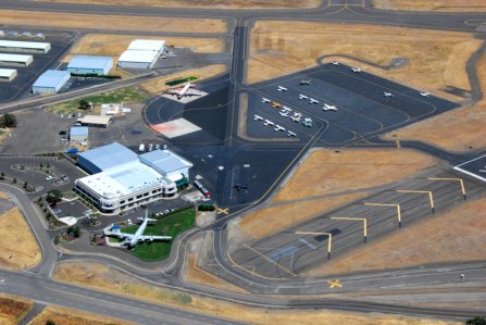
What I can offer though, are a few of the least smoky pix of our passage from Medford. ATC kindly cleared us for left departure over town, so I snapped Medford Air where the plane that landed as we took off was parking right where we’d just been.

0777 Medford Air Services

0777 Medford Air Services

The old four-engine tanker on public display lower-left is where we stood in the dark waiting for a taxi to our hotel Saturday night. To the right of the tail is a yellow X and just above that is the dark-colored plane parking where we’d been. There are several other interesting planes at M.Air, including a jet with the tail blown off during an experimental fuel test. The FBO owner had been climbing through 3kAGL on takeoff when the aft section of the engine and part of the tail exploded. Somehow he’d managed to turn and make a safe landing. The jet is now inside the hangar with tail section and wings removed and a replacement engine waiting nearby. Pretty amazing to look at the remains of the old engine and contemplate what that was like for the pilot!

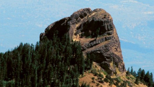
Climbing over the ridge past Ashland we spotted Shasta, but the smoke in that direction (and for nearly the entire remainder of our flight) was so thick the pix are horrible. Close by though was this rock outcrop I call the Cowboy Hat.

0786 Pilot Rock

0786 Pilot Rock

Seems like gMaps calls it Pilot Rock but I still like Cowboy Hat better from this angle. 🙂

Turning away from I-5 toward the coast our ride got smoky and lumpy for a while. Well out into the Marble Mountain/Six Rivers area something fascinated me about this settlement on a bend in the Salmon River.

0787 Salmon River

0787 Salmon River

I like to imagine people standing on those shores hauling a Winter supply of fish ashore for smoking. Think there’s any chance that salmon still make it up this river, or is the name a sad reminder of the era before “progress” came to the CA/OR border area?

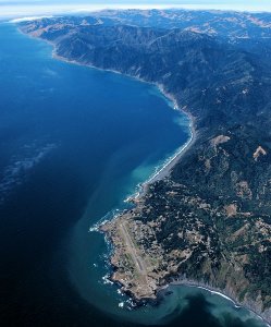
The second-least smoky area we flew that day was Shelter Cove. We’d thought about stopping there for lunch, but had left Medford later than planned and the weather was iffy. The strong wind blowing us South was smooth up here, but promised an interesting landing if we tried that. The low clouds zipping South a mile or so offshore could also rush in to prevent our continued flight as they were already doing for countless pilots we heard on the radio around Arcata.

0802 Shelter Cove

0802 Shelter Cove

Trying to imagine how a place so very exposed to the ravages of the deep Pacific could provide “shelter,” I finally spotted the nook with a small breakwater near the center-bottom of this pic (click to enlarge). Notice how the current is running North along the shoreline into the distance while the prevailing wind typically blows strongly to the South. Interesting place to operate boats and planes. We were up at probably 8-9000 feet to provide ample landing alternatives for the forest crossing, so even the relatively light haze here is pretty noticeable. A few miles away toward the South the smoke hung in an orange pall.

It was nice to see so many large vineyards welcoming us home to CA, and this one on a hillside East of Healdsburg offers some interesting shapes as rows of different grape varieties follow the contours.

0815 Hillside Shapes

0815 Hillside Shapes

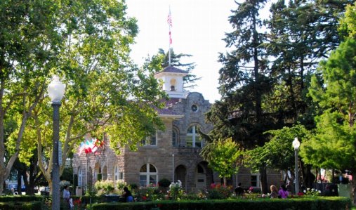
After deciding not to stop at Santa Rosa as we had on a previous flight, we tried something new by nipping into the little “Skypark” at Sonoma. With the pickup loaned us by the airport manager we took a very short tour into town and parked at the picturesque main square.

0819 Sonoma City Hall

0819 Sonoma City Hall

Across the street behind me is the Basque Cafe & bakery where we not only found a very good sandwich, but a variety of exceptional cookies at $1 each. My fav is the chewy chocolate. Anne bought a loaf of their bread to share with Nancy (unless we eat it all today!).

0822 Basque Cafe

0822 Basque Cafe

That’s it on the right, and behind is an arcada with lots more shops. Now if you’ve never tasted Basque food I hope you get the chance. The best meal we ever had was at La Taverna Basque in St. Jean de Luz, France. This bakery has kindled my desire for more actively seeking out Basque eateries!

Takeoff with nearly full fuel on the short runway with strong crosswind and trees at both ends was interesting. We put considerable trust in Tripp to make it relatively effortless, and she did. It would have been impossible with Flash, even at a comparable portion of gross weight (which would have been hundreds of pounds less). Listening on frequency and announcing our position before and during takeoff but hearing no other calls, my hope was that no other aircraft were operating near the airport. Imagine our surprise then to see a WWII era P-40 doing loops half a mile from the airport at 2kAGL! Never did manage to get a response from it, and once it looked as if we were a mock target. I assured Anne that the pilot surely must notice us, and was both highly skilled and motivated to take good care of what is probably a million dollar airplane. Needless to say, I climbed at full power until well away from Sonoma.

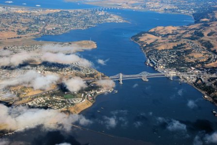
This brings us to the last decent photo of our trip, passing the Vallejo area. Since childhood I’ve always found it intriguing to look at the rows of mothballed ships moored just out of view at the top-left of this photo.

0825 Vallejo Area

0825 Vallejo Area

The entire bay off to the right was covered with low clouds, so we climbed high and to the East. This put us somewhat in the way of airlines descending into the Bay Area, so we added some entertainment for ATC. One jet was ordered to descend below our path but did it too gently, so ATC told them to hold 500′ above us and warned us of possible wake turbulence. Though he told us where to look for each other for extra safety, neither plane could spot the other until I heard the annoyed airline pilot remark to ATC that he had an “RA” (presumably the “A” has to do with Avoidance). I tilted up our wing in time to finally spot him 500′ higher initiating an abrupt turn and climb. It was reassuring that all of us were taking the proper precautions, and that we also had benefit of the “Required Avoidance” computer in the airliner. In a few years we’ll also have the new GPS-based “next gen” system being implemented by the FAA. I hope flying can always be this safe, and still be so much fun for VFR flyers like us. Every time I hear some pour soul following strictly-defined IFR lines in the sky, I’m glad again to have chosen to use the funds required to earn that IFR license – flying freely around the continent VFR instead. It will also be nice when playful P-40s like our Sonoma companion have automatic GPS next gen info on our location and vice versa.

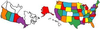
So today we’re resting, beginning to clean and unpack, and already casually talking about where we might go next. When fires abate and weather looks good, we’re eager to visit CO and get back up to OR & WA. Later in the Fall we hope to visit the other remaining continental U.S. state we haven’t seen: Arkansas. Further in the future is probably renting a plane in HI, and maybe somehow finding a way for Tripp to see Europe (maybe across the Aleutians?). For now, we have another trip to remember and dream about and an updated map of states & provinces we’ve landed in.

States & Provinces Flown

States & Provinces Flown

Pleasant Surprise

We planned to fly down the coast from Medford, but not long after leaving I-5 heading southwest we could see a solid low cloud layer completely covering the water. Tomorrow I’ll post some pix of a few clear areas we saw, but before long we headed inland along the 101. We decided to stop at Sonoma for a stretch, lunch, and fuel for Tripp. The landing was fun, with a short (2500 ft.) runway with trees at both ends and strong gusting crosswind, but easier than several of our landings on the Big Adventure flight last Fall. Ron the airport manager loaned us his pickup so we could drive the two miles into town for a sandwich. What a glorious little community!

From there we went southeast to clear the complex airspace over the Bay Area. We’d planned to fly over the Golden Gate and possibly SF, but the whole bay was covered in a blanket of white (another great reason to go along the eastern foothills). Soon we’d dialed in SBA on both GPSs and were headed directly for home. Then our thoughts turned to low clouds and fog. As night fell at about Paso Robles we were high over familiar terrain, and could pick out the lights of SLO and Oceano which was amazingly in the clear. But over Santa Maria hung some low ragged clouds. Once we could pick up the aviation weather radio from Santa Ynez we at least knew it would be possible to camp there if SBA was like most of the coast under the blanket. Then with everything set for maximum range we could dimly hear SBA weather say “landing Runway 25.” Now for anyone who knows this airport that can only mean one thing: clear skies!! 🙂

So thanks to this pleasant surprise we are now sitting amid piles of stuff (amazingly tall, given that they all came from trusty Tripp), breathing stale air with all the fans going, and beginning to enjoy the pleasures that only Home can bring. We gave each other a quick Alexander treatment, and now I’m sipping a glass of pinot. Life is so very sweet. It will take days for us to put things back into some semblance of order, and the rest of our lives to process the magnificent adventure we’ve just had from SBA to Soo to Ketch and back. Even typing those few words my head is brimming with unbelievable images and delightful memories. I may never get over the surprise of our good fortune in finding each other, building a life together that is perfect for us, enjoying the warmth of family and friends, still having good health, and even having access to flight and enough funds remaining to fly off on adventures like this. What a pleasant surprise indeed! My heart is full.

2010/08/08

Anne Won’t Stop

As I finished shaving just now and Anne was still typing feverishly on all her pent up blog posts, she titled this photo for me.

0375 Anne Won't Stop

0375 Anne Won't Stop

When I silently picked up her camera from the table by her right hand, the serious furrowed focus associated with her blizzard of typing instantly transformed into that brilliant giggling girl I love so deeply as she said, “Anne won’t stop.”

In case you’re wondering, I’ve already resolved to buy her a better laptop! I absolutely love that she’s beginning to blog, and she needs a better tool for that. This morning I walked the few steps we were too tired to take last night, and borrowed the cable so she could plug hers in rather than try to use the weak wifi in our room.

All this of course has me thinking about Life, Meaning and Love on this first day of our tenth Official year (we’ve been married by my definition since 1983, but our 18 year “engagement” before 8/7/01 is another and rather long story). One of the things I most enjoy about our time together is Noticing. We’ve helped each other to joyfully notice ourselves, each other, our environment and the relatively small slice of our planet’s billions of people that we’ve had the pleasure to encounter. Not just those like the girl dedicated to her cheerful work cleaning rooms and stocking the free breakfast room here. Nor even just the people we pass once on the street and never see again. Some of the latter leave us with a treasured “snippet” of their conversation, and many a glimpse of an expression that conveys a slice of what was in their consciousness during that few seconds. Beyond those, ever more often we strive to notice everyone and everything, because in that noticing we feel more alive and connected with our world.

So some of this was going on in me when I noticed her typing and tried to capture some essence of Her to preserve for myself, to share with her, and to share with anyone taking the time to read this. May these few words help us to wake up to the incredible beauty within and around us.

MT – our anniversary

Filed under: Aviation,by Anne,Happiness,Has Photos,NxNW Adventure — Anne @ 18:15

Quick photos as we’re about to leave our hotel in Medford, OR.

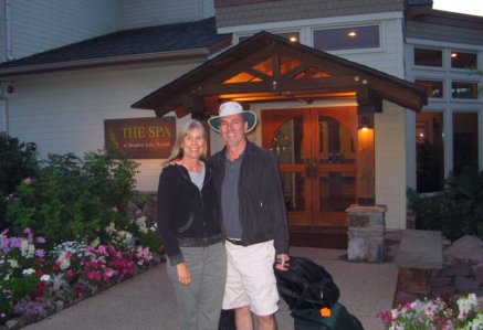
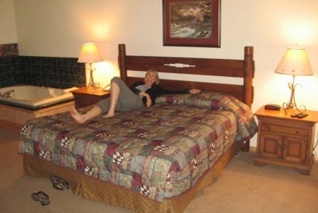
Here’s our anniversary hotel in Glacier Park, Montana:  The airport folks had already called all the hotels in town for other people and by the time we arrived the Meadow Lake Resort was the only place available.  It just happened that way. Glacier had one room left, pricier than our usual, and it was this one – Lucky it was also our anniversary!

0348 Meadow Lake Resort_J&A

0348 Meadow Lake Resort J&A

0352 Resort Room_A

0352 Resort Room - Anne enjoys

Notice hot tub/jacuzzi in corner!

0355 Resort Room View

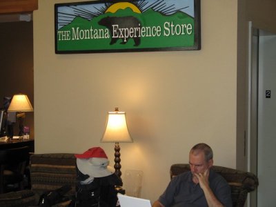
And here is a view I have had numerous times on our trip. This is something John does at some point every flying day or eve or both.  I so appreciate seeing him do this.  He pores over charts about weather, turbulence, smoke – and from that accumulation of information, plans our routes, and keeps us safe and happy!  Our luggage next to him, his wide-brimmed hat, my red Paris cap.  In the lobby at the hotel:

0360 John Plans our Tripp trips

0360 John Plans our Tripp trips

by ~Anne

« Previous Page — Next Page »

Create a free website or blog at WordPress.com.